COST Action 3DForEcoTech conducted a survey among participants of its key activities –including Summer Schools, Short-Term Scientific Missions (STSMs), workshops, virtual mobilities, and conferences – to evaluate the long-term impact of its training initiatives. The questionnaire assessed how participation influenced practical skills, motivation, research focus, scientific outputs, and professional networking, with a particular focus on the use and application of terrestrial LiDAR and ground-based 3D technologies. These insights enable 3DForEcoTech to evaluate the effectiveness of its activities and to inform the design of future training formats that meet the evolving needs of researchers at the intersection of forest ecology, remote sensing, and 3D terrestrial technologies.
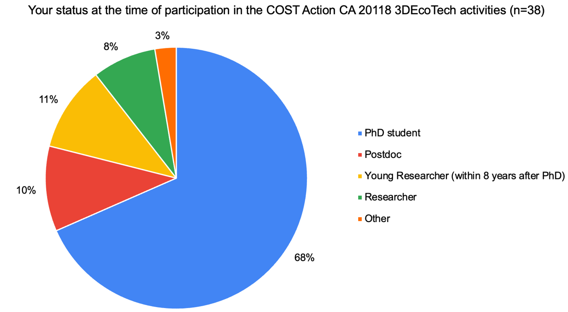
A total of 38 respondents (participants of 3DForEcoTech activities) took part in the survey. The majority of respondents were PhD students, representing 68% of all respondents. This indicates that the training activities primarily attracted individuals at an early stage of their research careers. Overall, the respondents’ profile demonstrates a strong focus on supporting the development of emerging scholars in the field.
The analysis of respondents’ prior experience with terrestrial LiDAR and ground-based 3D scanning suggested that most respondents had some familiarity with these technologies before participation (mean value 4.03 out of 5 points). However, the relatively high standard deviation of 1.69 highlights that the groups were heterogeneous in terms of technical background and prior exposure to LiDAR and 3D scanning methods.
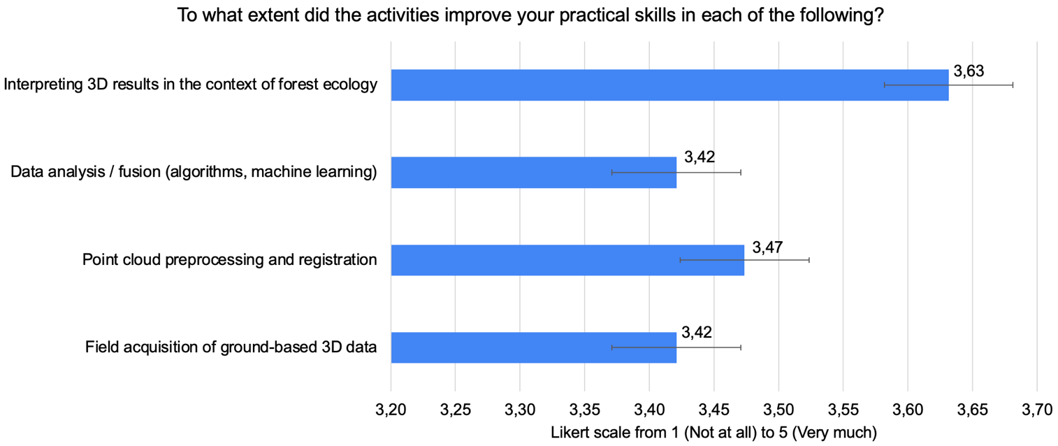
Based on their participation in the 3DForEcoTech activities, respondents evaluated improvements in their practical skills across four key areas. The highest gains were observed in interpreting 3D results within the context of forest ecology (mean = 3.63; SD = 1.13) and in point cloud preprocessing and registration (mean = 3.47; SD = 1.16).
Participation in the activities substantially enhanced respondents’ motivation to apply terrestrial LiDAR and ground-based 3D technologies in their research: 63% of respondents selected the highest score (5), and 26% rated their motivation increase as 4.
Analysis of follow-up actions showed high post-event engagement: 66% of respondents conducted their own field scanning, 53% – used training or example data, 26% – adapted algorithms or workflows, 32% – co-authored publications or technical reports and 21% – submitted project or grant proposals involving terrestrial LiDAR. Only 8% of respondents reported no follow-up action.
The main barriers to the full implementation of terrestrial LiDAR and ground-based 3D technologies were the high cost of equipment (39%) and the technical complexity of data processing (37%). These were followed by a lack of time or resources (29%) and limited access to equipment or laboratories (16%). Lack of institutional or supervisor support was mentioned less frequently (13%), but still represents an important structural barrier.
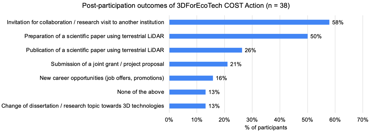
Participation in 3DForEcoTech activities led to a range of positive outcomes: invitations for collaboration or research visits – 58%, preparation of scientific papers using terrestrial LiDAR – 50%, publication of scientific papers – 26%, and submission of joint grants – 21%. Fewer respondents indicated new career opportunities (16%) or a change of dissertation/research topic toward 3D technologies (13%). Overall, the program primarily fostered scientific collaboration and research outputs.
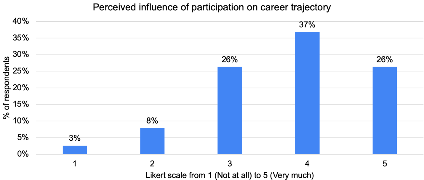
Participation in the activities positively influenced respondents’ career development, with an average rating of 3.76 points out of 5 (SD = 1.02). Most respondents rated the impact as moderate to high (37% gave a score of 4 and 26% gave a score of 5), while low ratings were rare, indicating meaningful professional development for the majority.
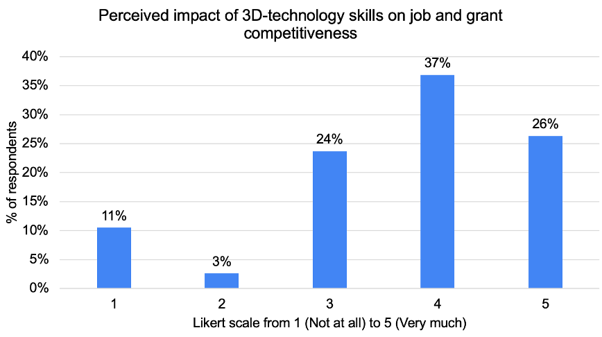
Acquiring 3D-technology skills had a positive effect on respondents’ perceived competitiveness for jobs and grants. On a scale from 1 (Not at all) to 5 (Very much), the average score was 3.66 with a standard deviation of 1.21. Most respondents rated the impact as moderate to high: 37% selected 4 and 26% selected 5, while low ratings of 1 and 2 were less common (11% and 3%, respectively). These results indicate that the 3D-technology skills gained contributed noticeably to improving respondents’ professional competitiveness.
Networking outcomes were strong: 84% of respondents reported new professional contacts, 16% – were unsure, and none reported no contacts. The average impact on professional networks in 3D terrestrial technologies, forest ecology, forest management and related fields was 3.97 (SD = 0.96), with most rating it as “significant” or “very significant” (42% and 32%).
Interdisciplinary collaboration was also effective: 37% of respondents reported opportunities to collaborate with experts from other fields “to a great extent”, 61% “to some extent”. Contacts often developed into concrete collaborations: 29% of respondents reported about joint research or data sharing, 21% – partial collaboration, 24% – collaboration in progress, 26% – no collaboration yet.
The analysis of respondents’ evaluations of the 3DForEcoTech activities for their professional development indicates a predominantly positive assessment. The average rating was 4.45 out of 5, demonstrating a strong overall impact. A majority of respondents (58%) rated the activities with the highest score (5), while 29% selected 4, and 13% gave a rating of 3. Notably, no respondents rated the activities below 3. The relatively low standard deviation (0.72) suggests a high level of consistency in the positive evaluations across the sample.
Majority of respondents (92%) perceive the 3DForEcoTech network as having strengthened the competitive position of European research and innovation within their respective study areas. Only a small proportion expressed uncertainty, difficulty in assessment, or disagreement (a total of 8%). Over 81% of respondents recognized a notable role of 3DForEcoTech in modernising forest research through the application of 3D terrestrial-based techniques and technologies.
Respondents provided valuable suggestions for improving future training initiatives. The most common recommendation was to increase hands-on learning and practical sessions (34%), covering the full workflow from data collection to analysis. Respondents also emphasized the need for longer events and regular follow-ups (21%), as well as additional materials and collaborative platforms (16%) to support independent work. Other suggestions included more interdisciplinarity and diversity (11%), better access to equipment and industry contacts (11%), and improved organization (5%). Overall, respondents expressed a clear preference for more intensive, practice-oriented and sustained learnings formats.
Respondents also highlighted their preferred training initiatives for the future. Longer practical internships were most requested (79%), followed by online courses on point cloud processing (74%) and post-school mentorship or supervised projects (66%). Access to hardware loan schemes or shared labs was mentioned less often (29%) but remains important for respondents with limited resources. These priorities provide clear guidance for enhancing the impact and accessibility of future training activities.
Text is authored by Oksana Pelyukh – Ukrainian National Forestry University